
Google-image the phrase “urban forest” and view what turns up. As one would expect, there are tree-lined residential streets and gentrified business districts, city parks and inviting paths that are lined with shady trees in full summer glory.

A forest hugs the banks of a river as it winds through farmland. (By U.S. Department of Agriculture - Public Domain, )
Less common are pictures of trees-lined rivers running through cities, even though those trees are members of the urban forest in their own right. In San Jose, we see riparian (river associated) trees along stretches of the Guadalupe River and Coyote Creek that have not been supplanted by concrete rip-rap (more about rip-rap later). They are distinct from other urban trees in that they are remnants of wild, native habitat. City trees, by contrast, are selected to satisfy human needs; they are planted to provide shade, beautiful blossoms, psychological balm, privacy, and higher property values.
In their natural state riparian corridors are rich in vegetation and wildlife. A presentation by the the Santa Clara Water District states that “native plants are ecologically best suited to the creek environment.” Plants and wildlife benefit from the sediment and organic material that streams transport and deposits on their banks. In this way, soil is enriched, erosion offset, and aquifers replenished. Native plants and aquatic life are adapted to seasonal variances in river flow, including annual flooding. As F. Thomas Griggs writes, “Cottonwood and willows, as well as all other riparian plant species, are directly dependent on patterns of sediment erosion and deposition.” Their seedlings grow river sandbars, which eventually rise to the level of the adjacent floodplain. Salmon and steelhead time their spawning runs in accordance with water conditions. In fact, Griggs states that “riparian corridors are the main migration routes for regional movement of all wildlife species,” including terrestrial mammals.
Dams disrupt these natural processes. They change a river’s volume or in the case of the San Joaquin River below Friant Dam, dewater it entirely. Damming in turn alters both the transport of life-giving materials, the water temperature (which can decimate temperature-sensitive salmon) longstanding seasonal patterns on which plants and wildlife rely. Invariably species decline in numbers.
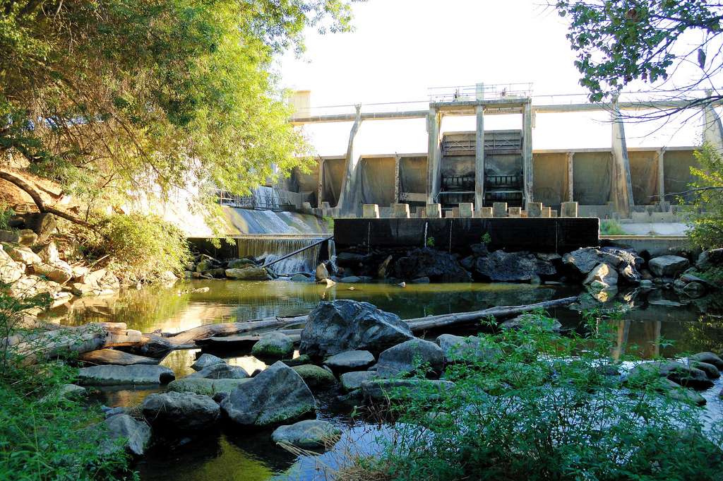
A dam towers over Los Gatos Creek, obstructing fish migration. ("Los Gatos Creek below Vasona Lake Dam, by Don DeBold CC 2.0)
As with tidal wetlands along the ocean and California’s bays, riparian woodlands have declined significantly in California—only an estimated 5% remain. One cause is the unpredictability of rivers and their natural tendency to flood, which in an urban setting can threaten human safety and cause widespread property damage. A case in point is San Francisquito Creek, which originates in the coastal hills behind Stanford University and Portola Valley and serves as a border between Palo Alto and Menlo Park before emptying into the Bay at East Palo Alto. In 1998 floodwaters flowed two miles south through Palo Alto before stopping near Embarcadero Road. Estimates of property damage from the flood are as high as $40 million. In response to this disaster, and in recognition of residents’ sensitivity to environmental issues, the San Francisquito Creek Joint Authority was formed. The goals of SFCJA are commendable: reduce flooding and save the creek.
Rip-rap and channelization are the more typical ways of protecting development along rivers. Forget the word’s suggestion of energy and song; rip-rap is the pile of rocks or construction debris that line river banks (and sometimes river bottoms). As Tim Palmer writes in Field Guide to California Rivers, rip-rap’s effects on riparian ecosystems are grave:

The LA River is formed by the Arryo Calabasas and Bell Creek. The head of the river is encased in concrete. (By Craig Dietrich - Flickr: Origin of the Los Angeles River in Canoga Park, CC BY-SA 2.0, )
“Channelization, stream straightening, building levees too close to the rivers, and lining the banks with rocks or construction debris (riprap) have all been done with the intent to protect adjacent lands from floods and bank erosion, but these activities destroy the bottom life of streams, eliminate natural pool-and-riffle sequences, warm the water by removing trees and vegetation, and halt the interaction between the river and its floodplain along with groundwater resources. What was once a biological bonanza of stream front forest becomes an excavated embankment of rock or concrete.”
Rip-rap, then, is material that is integral in changing rivers to flood controls. Alameda Creek, which originates east of the Bay in the hills beyond the Sunol Regional Wildnerness , is an example. It flows in riparian glory through Niles Canyon alongside Highway 84 until it reaches the outskirts of suburban sprawl just before Niles. There the creek has a bottom layer of rip-rap and is dammed. For the remaining 11 miles of its flow to the Bay, it is flanked by trapezoidal levees that are reinforced with rip-rap.
Another problem in preserving riparian areas is neglect. If we are indifferent to the state of our local rivers, not to mention the homeless who camp on their banks, urban riparian zones become trash-ridden and polluted. A key force in revitalizing these areas locally is the South Bay Clean Creeks Coalition. Founded almost 20 years by Executive Director Steve Homes, the group reckons it has removed 125 tons of trash from local creeks (one ton was removed last fall when Mr. Homes led AmeriCorps members of Our City Forest and other volunteers on a morning clean-up of Coyote Creek).

Coyote Creek, one of the most polluted rivers in the Bay Area, flows through San Jose. ("Lots of empties" by Tom Clifton , CC 2.0 Noncommercial)
While San Jose’s streams and adjacent woodlands cannot be exactly as they once were, anymore than grizzly bears can be reintroduced to Kelly Park, we can value, protect, and care for them. The efforts of Steve Homes’ group in restoring and revitalizing local streams are encouraging: beavers are returning to Los Gatos Creek as are Chinook salmon and steelhead there and elsewhere. We can turn things around.